Educational excursions

Lucca-Pontedera Bagni di Casciana ex-Railway

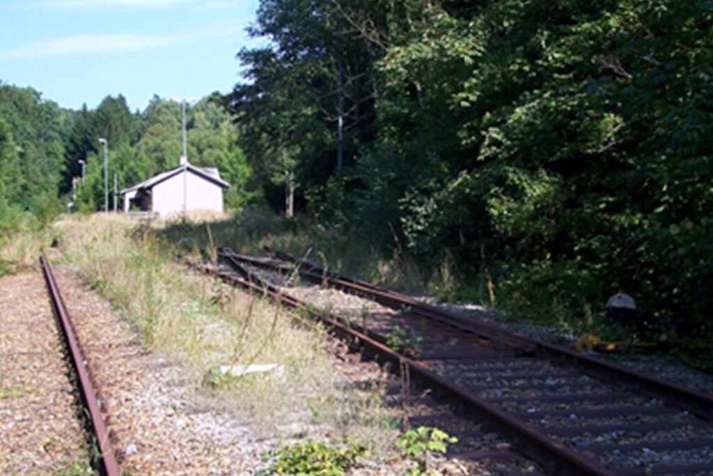
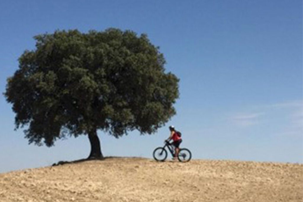
website: / website: / website: website: website: website: website: / / / / / Owner of the abandoned railway: Italian Railways of the State (Ferrovie dello Stato) Owner of the abandoned railway: Italian Railways of the State (Ferrovie dello Stato) Owner of the abandoned railway: Owner of the abandoned railway: Owner of the abandoned railway: Owner of the abandoned railway: Owner of the abandoned railway: Italian Railways of the State (Ferrovie dello Stato) Italian Railways of the State (Ferrovie dello Stato) Italian Railways of the State (Ferrovie dello Stato) Italian Railways of the State (Ferrovie dello Stato) Italian Railways of the State (Ferrovie dello Stato) gpx file: gpx file: gpx file: gpx file: gpx file: The Lucca – Pontedera ancient railway, a project of 25.3 km line long, was inaugurated in October 1928, after 6 years of works. During the Second World War the line was destroyed by bombing by the allies. Even if the line was largely rebuilt, in 1958 was officially abandoned. The track, generally covered by spontaneous vegetation, is not always visible. The line passed through the cities of: Lucca, Parezzana Toringo, San Leonardo-Sant’Andrea, San Ginese-Pieve di Compito, Colle di Compito,Buti-Cascine, Vicopisano-Bientina, Calcinaia, Pontedera. Many of the existing bridges have collapsed. In the old railway stations it is possible to admire several ruins, such as the Subalvea gallery, that passes under Visona Torrent. Near the city of Calcinaia, there is a bridge over the Arno river: 2 of 6 arches are still visible, the other 4 have been bombed. The third best-preserved work is a series of intersections near Via Pontemaggiore in San Leonardo in Treponzio: here there is an iron bridge over a river and a perfectly preserved arched bridge. The Lucca – Pontedera ancient railway, a project of 25.3 km line long, was inaugurated in October 1928, after 6 years of works. During the Second World War the line was destroyed by bombing by the allies. Even if the line was largely rebuilt, in 1958 was officially abandoned. The track, generally covered by spontaneous vegetation, is not always visible. The line passed through the cities of: Lucca, Parezzana Toringo, San Leonardo-Sant’Andrea, San Ginese-Pieve di Compito, Colle di Compito,Buti-Cascine, Vicopisano-Bientina, Calcinaia, Pontedera. Many of the existing bridges have collapsed. In the old railway stations it is possible to admire several ruins, such as the Subalvea gallery, that passes under Visona Torrent. Near the city of Calcinaia, there is a bridge over the Arno river: 2 of 6 arches are still visible, the other 4 have been bombed. The third best-preserved work is a series of intersections near Via Pontemaggiore in San Leonardo in Treponzio: here there is an iron bridge over a river and a perfectly preserved arched bridge. Total distance: 37548 mTotal climbing: 0 mTotal descent: 0 m Total distance: 37548 m Total distance: 37548 m Total climbing: 0 m Total climbing: 0 m Total descent: 0 m Total descent: 0 m The old abandoned railway passes through many interesting cities, among them: Lucca, one of the most fascinating and best-preserved mediaeval cities in Italy, Pontedera and Calcinaia, 2 small towns that are 3 km distant from each other; Vicopisano, Italian town located between the course of the Arno, famous for the Fortress of Brunelleschi; Medieval town Bientina. The most important festivals in the area are: Medieval Festival of Vicopisano, in September Lucca Comics, between October and November Palio Of Bientina, in July Another point of interest in the area is Lake Gherardesca, located in an area of Castelvecchio di Compito, in Capannori. The area of the lake is ideal for excursions, walks, birdwatching and nature photography. have a peek at these guys The old abandoned railway passes through many interesting cities, among them: Lucca, one of the most fascinating and best-preserved mediaeval cities in Italy, Pontedera and Calcinaia, 2 small towns that are 3 km distant from each other; Vicopisano, Italian town located between the course of the Arno, famous for the Fortress of Brunelleschi; Medieval town Bientina. The most important festivals in the area are: Medieval Festival of Vicopisano, in September Lucca Comics, between October and November Palio Of Bientina, in July Another point of interest in the area is Lake Gherardesca, located in an area of Castelvecchio di Compito, in Capannori. The area of the lake is ideal for excursions, walks, birdwatching and nature photography. Medieval Festival of Vicopisano, in September Lucca Comics, between October and November Palio Of Bientina, in July Medieval Festival of Vicopisano, in September Lucca Comics, between October and November Palio Of Bientina, in July Credits: Matteo Bini Credits: Matteo Bini Credits: Matteo Bini Credits: Matteo Bini Credits: Matteo Bini Credits: Matteo Bini Credits: Matteo Bini Credits: Matteo Bini The ex-railway could be suitable for carrying out plenty of sports and activities that can keep people entertained: Hiking, cycling, natural and educational excursions, walking and trekking and running, In the ecological reserve “Gherardesca’s lake, near Monte Pisano, some organizations organize trekking activities and walking routes to discover the biodiversity of the lake and the beauty of the area. The ex-railway could be suitable for carrying out plenty of sports and activities that can keep people entertained: Hiking, cycling, natural and educational excursions, walking and trekking and running, In the ecological reserve “Gherardesca’s lake, near Monte Pisano, some organizations organize trekking activities and walking routes to discover the biodiversity of the lake and the beauty of the area. Credits: Matteo Bini Credits: Matteo Bini Credits: Matteo Bini Credits: Matteo Bini According to the potential greenway project, pedestrians, bike and mountain bike will be able to use the track. The itinerary is quite easy and passes through secondary asphalt roads, dirt roads sometimes with uneven surface. For this reason, at the moment the track is not equipped for people with reduced mobility. The overall objective of the potential reconversion project Lucca-Pontedera tourist cycleway is the promotion of the Tuscan area and the connection between local businesses, gastronomic traditions and the environmental value. The goal of the project is the

Lucca-Pontedera Bagni di Casciana ex-Railway Read More »

The Dobermannsdorf – Loidesthal

website: website: website: website: website: Owner of the abandoned railway: State of Lower Austria Owner of the abandoned railway: State of Lower Austria Owner of the abandoned railway: Owner of the abandoned railway: Owner of the abandoned railway: Owner of the abandoned railway: Owner of the abandoned railway: State of Lower Austria State of Lower Austria State of Lower Austria State of Lower Austria State of Lower Austria gpx file: gpx file: gpx file: gpx file: gpx file: The potential greenway with a total distance of around 15 kilometers along the former railway line. The villages of Palterndorf, Dobermannsdorf, Gösting, Zistersdorf, Eichhorn, Loidesthal, Blumenthal, Windisch-Baumgarten, Großinzersdorf and Gaiselberg will be integrated into the cycle path network. The potential greenway with a total distance of around 15 kilometers along the former railway line. The villages of Palterndorf, Dobermannsdorf, Gösting, Zistersdorf, Eichhorn, Loidesthal, Blumenthal, Windisch-Baumgarten, Großinzersdorf and Gaiselberg will be integrated into the cycle path network. The potential greenway with a total distance of around 15 kilometers along the former railway line. The villages of Palterndorf, Dobermannsdorf, Gösting, Zistersdorf, Eichhorn, Loidesthal, Blumenthal, Windisch-Baumgarten, Großinzersdorf and Gaiselberg will be integrated into the cycle path network. site Total distance: 6436 mTotal climbing: 0 mTotal descent: 0 m Total distance: 6436 m Total distance: 6436 m Total climbing: 0 m Total climbing: 0 m Total descent: 0 m Total descent: 0 m The connections to the international Eurovelo9 and the Kamp-Thaya-March-Radweg (KTM): There is a direct connection between the new cycling facility and the regional “Muskateller” and “Traminer” cycle routes, as well as the connection to the international cycle route Eurovelo 9 from Vienna to Breclav and to the Lower Austrian main cycle route Kamp-Thaya-March-Radweg. These connections indicate that the new greenway, cycle path or special heritage will be linked to existing cycling routes and this will provide more options for recreational cycling and tourism. Retrieved from Google Maps. Unused railway station on Dobermannsdorf Retrieved from Google Maps. Unused railway station on Dobermannsdorf Retrieved from Google Maps. Unused railway station on Dobermannsdorf Retrieved from Google Maps. Unused railway station on Dobermannsdorf Retrieved from Google Maps. Unused railway station on Dobermannsdorf Retrieved from Google Maps. Unused railway station on Dobermannsdorf Retrieved from Google Maps. Unused railway station on Dobermannsdorf Retrieved from Google Maps. Unused railway station on Dobermannsdorf The railway between Dobermannsdorf and Loidesthal is planned to be repurposed as a greenway, offering a variety of sport and leisure activities such as cycling, walking, hiking, rollerblading, skateboarding, wildlife and nature observation and picnics. The greenway will also connect different villages and communities, providing a safe and scenic route for visitors and locals. It will also be connected to existing cycling routes, offering more options for recreational cycling and tourism. There are also tourist attraction centers on the former railway line such as Wehrturm, Memorial Park Kriegerdenkmal bei Wallfahrtskirche Maria Moos, Weinpresse Hauerbaum. (The touristic areas on the route were researched on Google earth.) The railway between Dobermannsdorf and Loidesthal is planned to be repurposed as a greenway, offering a variety of sport and leisure activities such as cycling, walking, hiking, rollerblading, skateboarding, wildlife and nature observation and picnics. The greenway will also connect different villages and communities, providing a safe and scenic route for visitors and locals. It will also be connected to existing cycling routes, offering more options for recreational cycling and tourism. There are also tourist attraction centers on the former railway line such as Wehrturm, Memorial Park Kriegerdenkmal bei Wallfahrtskirche Maria Moos, Weinpresse Hauerbaum. (The touristic areas on the route were researched on Google earth.) The railway between Dobermannsdorf and Loidesthal is planned to be repurposed as a greenway, offering a variety of sport and leisure activities such as cycling, walking, hiking, rollerblading, skateboarding, wildlife and nature observation and picnics. The greenway will also connect different villages and communities, providing a safe and scenic route for visitors and locals. It will also be connected to existing cycling routes, offering more options for recreational cycling and tourism. There are also tourist attraction centers on the former railway line such as Wehrturm, Memorial Park Kriegerdenkmal bei Wallfahrtskirche Maria Moos, Weinpresse Hauerbaum. (The touristic areas on the route were researched on Google earth.) (The touristic areas on the route were researched on Google earth.) Potential users of the railway greenway include local residents, cyclists, walkers/hikers, rollerbladers/ skateboarders, families, nature enthusiasts, and tourists. The greenway offers safe, convenient, and scenic options for transportation, recreation, and nature observation. The municipality of Zistersdorf, the market town of Palterndorf – Dobermannsdorf and the state of Lower Austria have decided to expand the no longer used railway line between the two municipalities for cyclists and thus connect the municipalities. Potential users of the railway greenway include local residents, cyclists, walkers/hikers, rollerbladers/ skateboarders, families, nature enthusiasts, and tourists. The greenway offers safe, convenient, and scenic options for transportation, recreation, and nature observation. The municipality of Zistersdorf, the market town of Palterndorf – Dobermannsdorf and the state of Lower Austria have decided to expand the no longer used railway line between the two municipalities for cyclists and thus connect the municipalities. Potential users of the railway greenway include local residents, cyclists, walkers/hikers, rollerbladers/ skateboarders, families, nature enthusiasts, and tourists. The greenway offers safe, convenient, and scenic options for transportation, recreation, and nature observation. The municipality of Zistersdorf, the market town of Palterndorf – Dobermannsdorf and the state of Lower Austria have decided to expand the no longer used railway line between the two municipalities for cyclists and thus connect the municipalities.

The Dobermannsdorf – Loidesthal Read More »

Hainfeld – Weißenbach an der Triesting, part of the LeobersdorferBahn that connected the Triestingtal and the Gölsental

website: website: website: website: website: Owner of the abandoned railway: The Lower Austrian Southwest Railways (NÖSWB) Owner of the abandoned railway: The Lower Austrian Southwest Railways (NÖSWB) Owner of the abandoned railway: Owner of the abandoned railway: Owner of the abandoned railway: Owner of the abandoned railway: Owner of the abandoned railway: The Lower Austrian Southwest Railways (NÖSWB) The Lower Austrian Southwest Railways (NÖSWB) The Lower Austrian Southwest Railways (NÖSWB) The Lower Austrian Southwest Railways (NÖSWB) The Lower Austrian Southwest Railways (NÖSWB) gpx file: gpx file: gpx file: gpx file: products gpx file: The railway line called “Weissenbach-Hainfeld” was opened in 1877 and was part of the Lower Austrian Southwest Railways (NÖSWB). It was almost 25 km long and was a single-track line with 3 intermediate stations, Altenmarkt-Thenneberg, Kaumberg, and court mountain and also had other stops, Kaumberg Markt, Altenmarkt an der Triesting, Tasshof, and Eberbach-Hocheck. The railway line was closed in 2004 and the tracks have been dismantled since 2015. One of the railway heritage of this railway is the concrete bridge over Hainfelder Straße (B18) over the Triesting at kilometer 28. Another important heritage of this railway is the Altenmarkt-Thenneberg station, located at kilometer 26.4 which had three through tracks and a short dead end track to the west, whose switch can be seen in front of the station building. Along the route, the bridge over the Triesting at kilometer 19.8 is also relatively new and it’s an important part of the railway heritage. Additionally, the Alter Gerichtsberg Tunnel and the Gerstbach Brücke are other significant heritage of this railway that are still preserved today. The railway line called “Weissenbach-Hainfeld” was opened in 1877 and was part of the Lower Austrian Southwest Railways (NÖSWB). It was almost 25 km long and was a single-track line with 3 intermediate stations, Altenmarkt-Thenneberg, Kaumberg, and court mountain and also had other stops, Kaumberg Markt, Altenmarkt an der Triesting, Tasshof, and Eberbach-Hocheck. The railway line was closed in 2004 and the tracks have been dismantled since 2015. One of the railway heritage of this railway is the concrete bridge over Hainfelder Straße (B18) over the Triesting at kilometer 28. Another important heritage of this railway is the Altenmarkt-Thenneberg station, located at kilometer 26.4 which had three through tracks and a short dead end track to the west, whose switch can be seen in front of the station building. Along the route, the bridge over the Triesting at kilometer 19.8 is also relatively new and it’s an important part of the railway heritage. Additionally, the Alter Gerichtsberg Tunnel and the Gerstbach Brücke are other significant heritage of this railway that are still preserved today. Total distance: 23818 mTotal climbing: 0 mTotal descent: 0 m Total distance: 23818 m Total distance: 23818 m Total climbing: 0 m Total climbing: 0 m Total descent: 0 m Total descent: 0 m Horse breeding farm along the route: Part of the Triesting Gölsental cycle route If the former railway line were to be converted into a greenway or cycle path, it could be used for a variety of sport and leisure activities. The relatively flat and smooth surface of the former railway line, along with its winding route through the mountainous region of the Triestingtal, would make it an ideal location for cycling. It could be used by both recreational and more serious cyclists for exercise, sightseeing, and commuting. The greenway or cycle path could also be used for hiking and walking. The winding route through the mountainous region of the Triestingtal would provide a scenic and relatively easy path for these activities. The route would provide a scenic and relatively easy walk through the mountainous region and could be enjoyed by people of all ages and abilities. Also, it could be a great opportunity for nature watching, birdwatching, wildlife observation, horseback riding, providing an opportunity for equestrian enthusiasts to explore the area on horseback. Additionally, it could also be used for rollerblading, skateboarding, scootering, and in line skating. If the former railway line were to be converted into a greenway or cycle path, it could be used for a variety of sport and leisure activities. The relatively flat and smooth surface of the former railway line, along with its winding route through the mountainous region of the Triestingtal, would make it an ideal location for cycling. It could be used by both recreational and more serious cyclists for exercise, sightseeing, and commuting. The greenway or cycle path could also be used for hiking and walking. The winding route through the mountainous region of the Triestingtal would provide a scenic and relatively easy path for these activities. The route would provide a scenic and relatively easy walk through the mountainous region and could be enjoyed by people of all ages and abilities. Also, it could be a great opportunity for nature watching, birdwatching, wildlife observation, horseback riding, providing an opportunity for equestrian enthusiasts to explore the area on horseback. Additionally, it could also be used for rollerblading, skateboarding, scootering, and in line skating. If the former railway line from Weissenbach to Hainfeld via the court mountain were to be converted into a greenway or cycle path, it could be used by a variety of potential users such as recreational and serious cyclists, hikers and walkers, nature enthusiasts, equestrian enthusiasts, families, tourists, rollerblading, skateboarding, Scootering enthusiasts for leisure, exercise, transportation, nature watching, birdwatching, wildlife observation, and as a destination for tourists. The success and popularity of the greenway or cycle path will depend on a variety of factors including location, accessibility, safety, and maintenance. (

Hainfeld – Weißenbach an der Triesting, part of the LeobersdorferBahn that connected the Triestingtal and the Gölsental Read More »

Continuation of the Guadarrama Greenway

click to read website: website: website: website: website: Owner/holder of the abandoned railway: ADIF (Administrador de Infraestructuras Ferroviarias) Owner/holder of the abandoned railway: ADIF (Administrador de Infraestructuras Ferroviarias) Owner/holder of the abandoned railway: Owner/holder of the abandoned railway: Owner/holder of the abandoned railway: Owner/holder of the abandoned railway: Owner/holder of the abandoned railway: ADIF (Administrador de Infraestructuras Ferroviarias) ADIF (Administrador de Infraestructuras Ferroviarias) ADIF (Administrador de Infraestructuras Ferroviarias) ADIF (Administrador de Infraestructuras Ferroviarias) ADIF (Administrador de Infraestructuras Ferroviarias) gpx file: gpx file: gpx file: gpx file: gpx file: The route follows an old railway at the gates of the big city of Madrid that extends along a pleasant landscape of cultivated fields. The itinerary goes through the villages of Navalcarnero and Villamanta. The route follows an old railway at the gates of the big city of Madrid that extends along a pleasant landscape of cultivated fields. The itinerary goes through the villages of Navalcarnero and Villamanta. The route follows an old railway at the gates of the big city of Madrid that extends along a pleasant landscape of cultivated fields. The itinerary goes through the villages of Navalcarnero and Villamanta. Total distance: 48585 mTotal climbing: 614 mTotal descent: -586 m Total distance: 48585 m Total distance: 48585 m Total climbing: 614 m Total climbing: 614 m Total descent: -586 m Total descent: -586 m Intermodality: Regional trains from Móstoles to Madrid, interurban buses. Connection with Greenway: Connected to the already existing Greenway of the Guadarrama. Considering the characteristics, the main activities are: hiking, mountain climbing, cycling, horse riding, natural and educational excursions.  Intermodality: Regional trains from Móstoles to Madrid, interurban buses. Connection with Greenway: Connected to the already existing Greenway of the Guadarrama. Considering the characteristics, the main activities are: hiking, mountain climbing, cycling, horse riding, natural and educational excursions.  Intermodality: Regional trains from Móstoles to Madrid, interurban buses. Intermodality: Connection with Greenway: Connected to the already existing Greenway of the Guadarrama. Connection with Greenway: Considering the characteristics, the main activities are: hiking, mountain climbing, cycling, horse riding, natural and educational excursions.  Considering the characteristics, the main activities are: hiking, mountain climbing, cycling, horse riding, natural and educational excursions.  The potential users are pedestrians, cyclists, mountain bike, horse riders, climbers.  There are no plans for transforming this abandoned railway into a greenway. The potential users are pedestrians, cyclists, mountain bike, horse riders, climbers.  There are no plans for transforming this abandoned railway into a greenway. The potential users are pedestrians, cyclists, mountain bike, horse riders, climbers.  The potential users are pedestrians, cyclists, mountain bike, horse riders, climbers.  There are no plans for transforming this abandoned railway into a greenway. There are no plans for transforming this abandoned railway into a greenway.

Continuation of the Guadarrama Greenway Read More »