Skating

Tua Railway (from Carvalhais till the Tua Station)

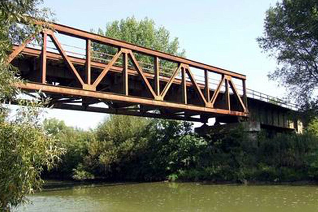
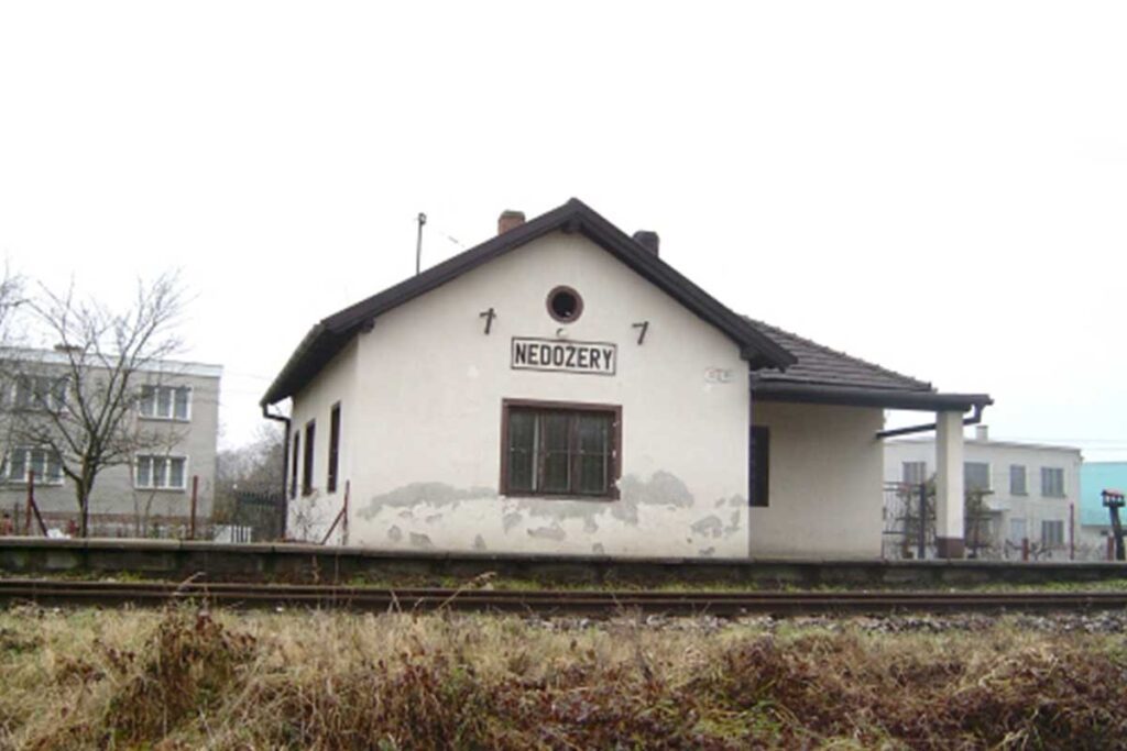
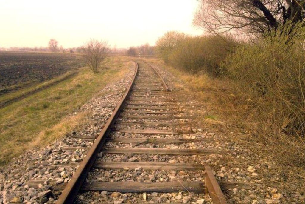
website: website: website: website: website: Owner/holder of the abandoned railway: IP Património/REFER Owner/holder of the abandoned railway: IP Património/REFER Owner/holder of the abandoned railway: Owner/holder of the abandoned railway: Owner/holder of the abandoned railway: Owner/holder of the abandoned railway: Owner/holder of the abandoned railway: IP Património/REFER IP Património/REFER IP Património/REFER IP Património/REFER IP Património/REFER gpx file: gpx file: gpx file: gpx file: gpx file: This is a long railway with 58,138 Km, the region it’s Trás-os-Montes, and this is a mountain area with hills, cliffs, valleys and lots of tunnels and bridges. Most of the railway goes always near the Tua River till the place where the Tua River connects Douro River that follows across the Douro valley till the Atlantic Ocean in the city of Porto. This is a long railway with 58,138 Km, the region it’s Trás-os-Montes, and this is a mountain area with hills, cliffs, valleys and lots of tunnels and bridges. Most of the railway goes always near the Tua River till the place where the Tua River connects Douro River that follows across the Douro valley till the Atlantic Ocean in the city of Porto. This is a long railway with 58,138 Km, the region it’s Trás-os-Montes, and this is a mountain area with hills, cliffs, valleys and lots of tunnels and bridges. Most of the railway goes always near the Tua River till the place where the Tua River connects Douro River that follows across the Douro valley till the Atlantic Ocean in the city of Porto. This is a long railway with 58,138 Km, the region it’s Trás-os-Montes, and this is a mountain area with hills, cliffs, valleys and lots of tunnels and bridges. Most of the railway goes always near the Tua River till the place where the Tua River connects Douro River that follows across the Douro valley till the Atlantic Ocean in the city of Porto. Total distance: 39993 mTotal climbing: 5 mTotal descent: -139 m Total distance: 39993 m Total distance: 39993 m Total climbing: 5 m Total climbing: 5 m Total descent: -139 m Total descent: -139 m This 58,138 Km long railway has lots of small stations in almost all villages that are crossed by the railway, eg. the village of Carvalhais. The biggest and most beautiful train station it’s in the city of Mirandela. Credits: Portugal Ferroviário Considering the characteristics, the potential activities are cycling, walking, running and skating.   Credits: Duarte Belo Potential users are Pedestrians, Runners, Bikes and Mountain Bikes, Skaters or Roller Skaters. For the horse riders it will depend on the surface that they will put in the greenway in the future because a hard surface it will be bad of the horses. At this moment for this 58,138 Km there’s no known plan. This 58,138 Km long railway has lots of small stations in almost all villages that are crossed by the railway, eg. the village of Carvalhais. The biggest and most beautiful train station it’s in the city of Mirandela. Credits: Portugal Ferroviário Considering the characteristics, the potential activities are cycling, walking, running and skating.   Credits: Duarte Belo Potential users are Pedestrians, Runners, Bikes and Mountain Bikes, Skaters or Roller Skaters. For the horse riders it will depend on the surface that they will put in the greenway in the future because a hard surface it will be bad of the horses. At this moment for this 58,138 Km there’s no known plan. This 58,138 Km long railway has lots of small stations in almost all villages that are crossed by the railway, eg. the village of Carvalhais. The biggest and most beautiful train station it’s in the city of Mirandela. Credits: Portugal Ferroviário Considering the characteristics, the potential activities are cycling, walking, running and skating.   Credits: Duarte Belo Potential users are Pedestrians, Runners, Bikes and Mountain Bikes, Skaters or Roller Skaters. For the horse riders it will depend on the surface that they will put in the greenway in the future because a hard surface it will be bad of the horses. At this moment for this 58,138 Km there’s no known plan. This 58,138 Km long railway has lots of small stations in almost all villages that are crossed by the railway, eg. the village of Carvalhais. The biggest and most beautiful train station it’s in the city of Mirandela. Credits: Portugal Ferroviário Considering the characteristics, the potential activities are cycling, walking, running and skating.   Credits: Duarte Belo Potential users are Pedestrians, Runners, Bikes and Mountain Bikes, Skaters or Roller Skaters. For the horse riders it will depend on the surface that they will put in the greenway in the future because a hard surface it will be bad of the horses. At this moment for this 58,138 Km there’s no known plan. This 58,138 Km long railway has lots of small stations in almost all villages that are crossed by the railway, eg. the village of Carvalhais. The biggest and most beautiful train station it’s in the city of Mirandela. This 58,138 Km long railway has lots of small stations in almost all villages that are crossed by the railway, eg. the village of Carvalhais. The biggest and most beautiful train station it’s in the city of Mirandela. This 58,138 Km long railway has lots of small stations in almost all villages that are crossed by the railway, eg. the village of Carvalhais. The biggest and most beautiful train station it’s in the city of Mirandela. This 58,138 Km long railway has lots of small stations in almost all villages that are crossed by the railway, eg. the village of Carvalhais. The biggest and most beautiful train station it’s in the city of Mirandela. Credits: Portugal Ferroviário Credits: Portugal Ferroviário Credits: Portugal Ferroviário Credits: Portugal Ferroviário Credits: Portugal Ferroviário Credits: Portugal Ferroviário Credits: Portugal Ferroviário Credits: Portugal Ferroviário Considering the characteristics, the potential activities are cycling, walking, running and skating.   Considering the characteristics, the potential activities are cycling, walking, running and skating.

Tua Railway (from Carvalhais till the Tua Station) Read More »

Zlaté Moravce – Lužianky railway

website: website: website: website: website: Owner of the abandoned railway: Slovak Republic Railways (Železnice Slovenskej republiky) Owner of the abandoned railway: Slovak Republic Railways (Železnice Slovenskej republiky) Owner of the abandoned railway: Owner of the abandoned railway: Owner of the abandoned railway: Owner of the abandoned railway: Owner of the abandoned railway: Slovak Republic Railways (Železnice Slovenskej republiky) Slovak Republic Railways (Železnice Slovenskej republiky) Slovak Republic Railways (Železnice Slovenskej republiky) Slovak Republic Railways (Železnice Slovenskej republiky) Slovak Republic Railways (Železnice Slovenskej republiky) gpx file: gpx file: gpx file: gpx file: gpx file: There are 6 stations between Lužianky and Zlaté Moravce (Drážovce, Podhorany, Žirany, Jelenec, Ladice, Sľažany). It simultaneously crosses the flat area of south Slovakia and also the hilly area of central Slovakia (Tribeč mountains). There are several bridges over the railway, viaducts on the rail too. There is a bridge over the river Nitra. There are 6 stations between Lužianky and Zlaté Moravce (Drážovce, Podhorany, Žirany, Jelenec, Ladice, Sľažany). It simultaneously crosses the flat area of south Slovakia and also the hilly area of central Slovakia (Tribeč mountains). There are several bridges over the railway, viaducts on the rail too. There is a bridge over the river Nitra. There are 6 stations between Lužianky and Zlaté Moravce (Drážovce, Podhorany, Žirany, Jelenec, Ladice, Sľažany). It simultaneously crosses the flat area of south Slovakia and also the hilly area of central Slovakia (Tribeč mountains). There are several bridges over the railway, viaducts on the rail too. There is a bridge over the river Nitra. There are 6 stations between Lužianky and Zlaté Moravce (Drážovce, Podhorany, Žirany, Jelenec, Ladice, Sľažany). It simultaneously crosses the flat area of south Slovakia and also the hilly area of central Slovakia (Tribeč mountains). There are several bridges over the railway, viaducts on the rail too. There is a bridge over the river Nitra. Total distance: 32231 mTotal climbing: 175 mTotal descent: -145 m Total distance: 32231 m Total distance: 32231 m Total climbing: 175 m Total climbing: 175 m Total descent: -145 m Total descent: -145 m Tribeč area offers many interesting hiking paths close to the city Nitra and can be accessible from the railway.  Tribeč is also very popular with mountain bikers since there are a lot of paths interweaving the hills. Intermodality: Lužianky station can be reached from Nitra by train and the train station is directly next to the bus station in Nitra. In Zlaté Moravce, stations are within 1,2 km from each other. Credits: https://kzmbojnice.railnet.sk/zastavka-nedozery-na-moduloch/ Considering the characteristics, the main activities are: cycling, walking, running, trekking, nordic walking, hiking, skating, mountain biking. Credits: https://kzmbojnice.railnet.sk/zastavka-nedozery-na-moduloch/ Since the railway is located in a flat area of the country mostly in a close proximity to the river Váh, it could be potentially visited by all people, even with reduced mobility. There is no steep incline and it should be accessible by anyone. There is no plan in action at the moment. Passenger transport was cancelled, it may still be used for cargo transport. Tribeč area offers many interesting hiking paths close to the city Nitra and can be accessible from the railway.  Tribeč is also very popular with mountain bikers since there are a lot of paths interweaving the hills. Intermodality: Lužianky station can be reached from Nitra by train and the train station is directly next to the bus station in Nitra. In Zlaté Moravce, stations are within 1,2 km from each other. Credits: https://kzmbojnice.railnet.sk/zastavka-nedozery-na-moduloch/ Considering the characteristics, the main activities are: cycling, walking, running, trekking, nordic walking, hiking, skating, mountain biking. Credits: https://kzmbojnice.railnet.sk/zastavka-nedozery-na-moduloch/ Since the railway is located in a flat area of the country mostly in a close proximity to the river Váh, it could be potentially visited by all people, even with reduced mobility. There is no steep incline and it should be accessible by anyone. There is no plan in action at the moment. Passenger transport was cancelled, it may still be used for cargo transport. Tribeč area offers many interesting hiking paths close to the city Nitra and can be accessible from the railway.  Tribeč is also very popular with mountain bikers since there are a lot of paths interweaving the hills. Intermodality: Lužianky station can be reached from Nitra by train and the train station is directly next to the bus station in Nitra. In Zlaté Moravce, stations are within 1,2 km from each other. Credits: https://kzmbojnice.railnet.sk/zastavka-nedozery-na-moduloch/ Considering the characteristics, the main activities are: cycling, walking, running, trekking, nordic walking, hiking, skating, mountain biking. Credits: https://kzmbojnice.railnet.sk/zastavka-nedozery-na-moduloch/ Since the railway is located in a flat area of the country mostly in a close proximity to the river Váh, it could be potentially visited by all people, even with reduced mobility. There is no steep incline and it should be accessible by anyone. There is no plan in action at the moment. Passenger transport was cancelled, it may still be used for cargo transport. Tribeč area offers many interesting hiking paths close to the city Nitra and can be accessible from the railway.  Tribeč is also very popular with mountain bikers since there are a lot of paths interweaving the hills. Intermodality: Lužianky station can be reached from Nitra by train and the train station is directly next to the bus station in Nitra. In Zlaté Moravce, stations are within 1,2 km from each other. Credits: https://kzmbojnice.railnet.sk/zastavka-nedozery-na-moduloch/ Considering the characteristics, the main activities are: cycling, walking, running, trekking, nordic walking, hiking, skating, mountain biking. Credits: https://kzmbojnice.railnet.sk/zastavka-nedozery-na-moduloch/ Since the railway is located in a flat area of the country mostly in a close proximity to the river Váh, it could be potentially visited by all people, even with reduced mobility. There is no steep incline and it should be accessible by anyone. There is no plan in action at the moment. Passenger transport was cancelled, it may still be used for cargo transport. Tribeč area offers many interesting hiking paths close to the city Nitra and can be accessible from the railway.  Tribeč is also very popular with

Zlaté Moravce – Lužianky railway Read More »

Nitrianske Pravno – Prievidza Railway

website: website: website: website: website: Owner of the abandoned railway: Slovak Republic Railways (Železnice Slovenskej republiky) Owner of the abandoned railway: Slovak Republic Railways (Železnice Slovenskej republiky) Owner of the abandoned railway: Owner of the abandoned railway: Owner of the abandoned railway: Owner of the abandoned railway: Owner of the abandoned railway: Slovak Republic Railways (Železnice Slovenskej republiky) Slovak Republic Railways (Železnice Slovenskej republiky) Slovak Republic Railways (Železnice Slovenskej republiky) Slovak Republic Railways (Železnice Slovenskej republiky) Slovak Republic Railways (Železnice Slovenskej republiky) . gpx file: gpx file: gpx file: gpx file: gpx file: The majority of the railway passes fields and a flat area of the country. Besides Nitrianske Pravno and Prievidza, it crossed only two other municipalities with stations in Nedožery any Pravenec. There is a tunnel over river Nitra near Pravenec village. The majority of the railway passes fields and a flat area of the country. Besides Nitrianske Pravno and Prievidza, it crossed only two other municipalities with stations in Nedožery any Pravenec. There is a tunnel over river Nitra near Pravenec village. The majority of the railway passes fields and a flat area of the country. Besides Nitrianske Pravno and Prievidza, it crossed only two other municipalities with stations in Nedožery any Pravenec. There is a tunnel over river Nitra near Pravenec village. The majority of the railway passes fields and a flat area of the country. Besides Nitrianske Pravno and Prievidza, it crossed only two other municipalities with stations in Nedožery any Pravenec. There is a tunnel over river Nitra near Pravenec village. Total distance: 10272 mTotal climbing: 78 mTotal descent: -2 m Total distance: 10272 m Total distance: 10272 m Total climbing: 78 m Total climbing: 78 m Total descent: -2 m Total descent: -2 m Intermodality: Bus station in Prievidza is located next to the train station and in Nitrianske Pravno, the distance from the bus stop is only 8 minutes on foot (750 m). There are a couple cycling paths crossing Nitrianske Pravno which can be easily accessed (Bojnický cyklookruh, Pravnianska radiála, Ponitrianska cyklomagistrála II. In Prievidza, people can visit the Motive power depot, which was marked as a national cultural monument. It is the most preserved depot in Slovakia with exhibitions of original technical equipment. Intermodality: Bus station in Prievidza is located next to the train station and in Nitrianske Pravno, the distance from the bus stop is only 8 minutes on foot (750 m). There are a couple cycling paths crossing Nitrianske Pravno which can be easily accessed (Bojnický cyklookruh, Pravnianska radiála, Ponitrianska cyklomagistrála II. In Prievidza, people can visit the Motive power depot, which was marked as a national cultural monument. It is the most preserved depot in Slovakia with exhibitions of original technical equipment. Intermodality: Bus station in Prievidza is located next to the train station and in Nitrianske Pravno, the distance from the bus stop is only 8 minutes on foot (750 m). Intermodality: Bus station in Prievidza is located next to the train station and in Nitrianske Pravno, the distance from the bus stop is only 8 minutes on foot (750 m). There are a couple cycling paths crossing Nitrianske Pravno which can be easily accessed (Bojnický cyklookruh, Pravnianska radiála, Ponitrianska cyklomagistrála II. There are a couple cycling paths crossing Nitrianske Pravno which can be easily accessed (Bojnický cyklookruh, Pravnianska radiála, Ponitrianska cyklomagistrála II. In Prievidza, people can visit the Motive power depot, which was marked as a national cultural monument. It is the most preserved depot in Slovakia with exhibitions of original technical equipment. In Prievidza, people can visit the Motive power depot, which was marked as a national cultural monument. It is the most preserved depot in Slovakia with exhibitions of original technical equipment. Considering the characteristics, the main activities are: cycling, walking, running, trekking, nordic walking, hiking, skating. Considering the characteristics, the main activities are: cycling, walking, running, trekking, nordic walking, hiking, skating. Considering the characteristics, the main activities are: cycling, walking, running, trekking, nordic walking, hiking, skating. Considering the characteristics, the main activities are: cycling, walking, running, trekking, nordic walking, hiking, skating. Since the railway is located in a flat area of the country, it could be potentially visited by all people, even with reduced mobility. There is no steep incline and it should be accessible by anyone. At the moment, passenger transportation is cancelled on the railway but very rarely it is used to access the quarry in Žirany. No greenway conversion action plan is in place. Since the railway is located in a flat area of the country, it could be potentially visited by all people, even with reduced mobility. There is no steep incline and it should be accessible by anyone. At the moment, passenger transportation is cancelled on the railway but very rarely it is used to access the quarry in Žirany. No greenway conversion action plan is in place. Since the railway is located in a flat area of the country, it could be potentially visited by all people, even with reduced mobility. There is no steep incline and it should be accessible by anyone. Since the railway is located in a flat area of the country, it could be potentially visited by all people, even with reduced mobility. There is no steep incline and it should be accessible by anyone. At the moment, passenger transportation is cancelled on the railway but very rarely it is used to access the quarry in Žirany. No greenway conversion action plan is in place. At the moment, passenger transportation is cancelled on the railway but very rarely it is used to access the quarry in Žirany. No greenway conversion action plan is in place.

Nitrianske Pravno – Prievidza Railway Read More »

Komárno – Kolárovo railway

website: website: website: website: website: Owner of the abandoned railway: Slovak Republic Railways (Železnice Slovenskej republiky) Owner of the abandoned railway: Slovak Republic Railways (Železnice Slovenskej republiky) view details Owner of the abandoned railway: Owner of the abandoned railway: Owner of the abandoned railway: Owner of the abandoned railway: Owner of the abandoned railway: Slovak Republic Railways (Železnice Slovenskej republiky) Slovak Republic Railways (Železnice Slovenskej republiky) Slovak Republic Railways (Železnice Slovenskej republiky) Slovak Republic Railways (Železnice Slovenskej republiky) Slovak Republic Railways (Železnice Slovenskej republiky) gpx file: gpx file: gpx file: gpx file: gpx file: The old railway passes through the southern region of Slovakia and is surrounded by vegetation and fields. River Váh flows in a close proximity to the railway with its tributaries. The railway passes 7 stations between Komárno and Kolárovo (Komárno school, Hadovce, Kameničná, Balvany, Čalovec, Violín, Kráľka). There is a bridge that crosses the Komárňanský Cannal and part of the railway goes alongside a small nature reserve SEV Dropie. Another bridge crosses the Kolárovo-Kameničná stream between Čalovec and Balvany stations. The old railway passes through the southern region of Slovakia and is surrounded by vegetation and fields. River Váh flows in a close proximity to the railway with its tributaries. The railway passes 7 stations between Komárno and Kolárovo (Komárno school, Hadovce, Kameničná, Balvany, Čalovec, Violín, Kráľka). There is a bridge that crosses the Komárňanský Cannal and part of the railway goes alongside a small nature reserve SEV Dropie. Another bridge crosses the Kolárovo-Kameničná stream between Čalovec and Balvany stations. The old railway passes through the southern region of Slovakia and is surrounded by vegetation and fields. River Váh flows in a close proximity to the railway with its tributaries. The railway passes 7 stations between Komárno and Kolárovo (Komárno school, Hadovce, Kameničná, Balvany, Čalovec, Violín, Kráľka). There is a bridge that crosses the Komárňanský Cannal and part of the railway goes alongside a small nature reserve SEV Dropie. Another bridge crosses the Kolárovo-Kameničná stream between Čalovec and Balvany stations. The old railway passes through the southern region of Slovakia and is surrounded by vegetation and fields. River Váh flows in a close proximity to the railway with its tributaries. The railway passes 7 stations between Komárno and Kolárovo (Komárno school, Hadovce, Kameničná, Balvany, Čalovec, Violín, Kráľka). There is a bridge that crosses the Komárňanský Cannal and part of the railway goes alongside a small nature reserve SEV Dropie. Another bridge crosses the Kolárovo-Kameničná stream between Čalovec and Balvany stations. Total distance: 25849 mTotal climbing: 21 mTotal descent: -25 m Total distance: 25849 m Total distance: 25849 m Total climbing: 21 m Total climbing: 21 m Total descent: -25 m Total descent: -25 m Near Kolárovo, there are old water mills which have been transformed into a Museum of windmills (Múzeum vodného mlynárstva, Lodný mlyn Kolárovo). Part of the railway goes alongside a small nature reserve SEV Dropie.  There already exists one cycle route between those two towns and the municipalities, but this path goes along the river Váh from the other side of the river. Intermodality: Bus station Komárno is located right next to the train station which makes transport to and from the railway very convenient. In Kolárovo, the bus station in app. 1,2 km from the train station and it is possible to reach it on foot. Near Kolárovo, there are old water mills which have been transformed into a Museum of windmills (Múzeum vodného mlynárstva, Lodný mlyn Kolárovo). Part of the railway goes alongside a small nature reserve SEV Dropie.  There already exists one cycle route between those two towns and the municipalities, but this path goes along the river Váh from the other side of the river. Intermodality: Bus station Komárno is located right next to the train station which makes transport to and from the railway very convenient. In Kolárovo, the bus station in app. 1,2 km from the train station and it is possible to reach it on foot. Near Kolárovo, there are old water mills which have been transformed into a Museum of windmills (Múzeum vodného mlynárstva, Lodný mlyn Kolárovo). Part of the railway goes alongside a small nature reserve SEV Dropie.  Near Kolárovo, there are old water mills which have been transformed into a Museum of windmills (Múzeum vodného mlynárstva, Lodný mlyn Kolárovo). Part of the railway goes alongside a small nature reserve SEV Dropie.  There already exists one cycle route between those two towns and the municipalities, but this path goes along the river Váh from the other side of the river. There already exists one cycle route between those two towns and the municipalities, but this path goes along the river Váh from the other side of the river. Intermodality: Intermodality: Bus station Komárno is located right next to the train station which makes transport to and from the railway very convenient. In Kolárovo, the bus station in app. 1,2 km from the train station and it is possible to reach it on foot. Bus station Komárno is located right next to the train station which makes transport to and from the railway very convenient. In Kolárovo, the bus station in app. 1,2 km from the train station and it is possible to reach it on foot. Considering the characteristics, the main activities are: cycling, walking, running, trekking, nordic walking, hiking, skating. Considering the characteristics, the main activities are: cycling, walking, running, trekking, nordic walking, hiking, skating. Considering the characteristics, the main activities are: cycling, walking, running, trekking, nordic walking, hiking, skating. Considering the characteristics, the main activities are: c ycling, walking, running, trekking, nordic walking, hiking, skating. Since the railway is located in a flat area of the country, it could be potentially visited by all people, even with reduced mobility. There is no steep incline and it should be accessible by anyone. At the moment, there is no effective plan for transforming this abandoned railway into a GW., since there is already an existing cycling path between Komárno and Kolárovo, on the

Komárno – Kolárovo railway Read More »

The Dobermannsdorf – Loidesthal

website: website: website: website: website: Owner of the abandoned railway: State of Lower Austria Owner of the abandoned railway: State of Lower Austria Owner of the abandoned railway: Owner of the abandoned railway: Owner of the abandoned railway: Owner of the abandoned railway: Owner of the abandoned railway: State of Lower Austria State of Lower Austria State of Lower Austria State of Lower Austria State of Lower Austria gpx file: gpx file: gpx file: gpx file: gpx file: The potential greenway with a total distance of around 15 kilometers along the former railway line. The villages of Palterndorf, Dobermannsdorf, Gösting, Zistersdorf, Eichhorn, Loidesthal, Blumenthal, Windisch-Baumgarten, Großinzersdorf and Gaiselberg will be integrated into the cycle path network. The potential greenway with a total distance of around 15 kilometers along the former railway line. The villages of Palterndorf, Dobermannsdorf, Gösting, Zistersdorf, Eichhorn, Loidesthal, Blumenthal, Windisch-Baumgarten, Großinzersdorf and Gaiselberg will be integrated into the cycle path network. The potential greenway with a total distance of around 15 kilometers along the former railway line. The villages of Palterndorf, Dobermannsdorf, Gösting, Zistersdorf, Eichhorn, Loidesthal, Blumenthal, Windisch-Baumgarten, Großinzersdorf and Gaiselberg will be integrated into the cycle path network. site Total distance: 6436 mTotal climbing: 0 mTotal descent: 0 m Total distance: 6436 m Total distance: 6436 m Total climbing: 0 m Total climbing: 0 m Total descent: 0 m Total descent: 0 m The connections to the international Eurovelo9 and the Kamp-Thaya-March-Radweg (KTM): There is a direct connection between the new cycling facility and the regional “Muskateller” and “Traminer” cycle routes, as well as the connection to the international cycle route Eurovelo 9 from Vienna to Breclav and to the Lower Austrian main cycle route Kamp-Thaya-March-Radweg. These connections indicate that the new greenway, cycle path or special heritage will be linked to existing cycling routes and this will provide more options for recreational cycling and tourism. Retrieved from Google Maps. Unused railway station on Dobermannsdorf Retrieved from Google Maps. Unused railway station on Dobermannsdorf Retrieved from Google Maps. Unused railway station on Dobermannsdorf Retrieved from Google Maps. Unused railway station on Dobermannsdorf Retrieved from Google Maps. Unused railway station on Dobermannsdorf Retrieved from Google Maps. Unused railway station on Dobermannsdorf Retrieved from Google Maps. Unused railway station on Dobermannsdorf Retrieved from Google Maps. Unused railway station on Dobermannsdorf The railway between Dobermannsdorf and Loidesthal is planned to be repurposed as a greenway, offering a variety of sport and leisure activities such as cycling, walking, hiking, rollerblading, skateboarding, wildlife and nature observation and picnics. The greenway will also connect different villages and communities, providing a safe and scenic route for visitors and locals. It will also be connected to existing cycling routes, offering more options for recreational cycling and tourism. There are also tourist attraction centers on the former railway line such as Wehrturm, Memorial Park Kriegerdenkmal bei Wallfahrtskirche Maria Moos, Weinpresse Hauerbaum. (The touristic areas on the route were researched on Google earth.) The railway between Dobermannsdorf and Loidesthal is planned to be repurposed as a greenway, offering a variety of sport and leisure activities such as cycling, walking, hiking, rollerblading, skateboarding, wildlife and nature observation and picnics. The greenway will also connect different villages and communities, providing a safe and scenic route for visitors and locals. It will also be connected to existing cycling routes, offering more options for recreational cycling and tourism. There are also tourist attraction centers on the former railway line such as Wehrturm, Memorial Park Kriegerdenkmal bei Wallfahrtskirche Maria Moos, Weinpresse Hauerbaum. (The touristic areas on the route were researched on Google earth.) The railway between Dobermannsdorf and Loidesthal is planned to be repurposed as a greenway, offering a variety of sport and leisure activities such as cycling, walking, hiking, rollerblading, skateboarding, wildlife and nature observation and picnics. The greenway will also connect different villages and communities, providing a safe and scenic route for visitors and locals. It will also be connected to existing cycling routes, offering more options for recreational cycling and tourism. There are also tourist attraction centers on the former railway line such as Wehrturm, Memorial Park Kriegerdenkmal bei Wallfahrtskirche Maria Moos, Weinpresse Hauerbaum. (The touristic areas on the route were researched on Google earth.) (The touristic areas on the route were researched on Google earth.) Potential users of the railway greenway include local residents, cyclists, walkers/hikers, rollerbladers/ skateboarders, families, nature enthusiasts, and tourists. The greenway offers safe, convenient, and scenic options for transportation, recreation, and nature observation. The municipality of Zistersdorf, the market town of Palterndorf – Dobermannsdorf and the state of Lower Austria have decided to expand the no longer used railway line between the two municipalities for cyclists and thus connect the municipalities. Potential users of the railway greenway include local residents, cyclists, walkers/hikers, rollerbladers/ skateboarders, families, nature enthusiasts, and tourists. The greenway offers safe, convenient, and scenic options for transportation, recreation, and nature observation. The municipality of Zistersdorf, the market town of Palterndorf – Dobermannsdorf and the state of Lower Austria have decided to expand the no longer used railway line between the two municipalities for cyclists and thus connect the municipalities. Potential users of the railway greenway include local residents, cyclists, walkers/hikers, rollerbladers/ skateboarders, families, nature enthusiasts, and tourists. The greenway offers safe, convenient, and scenic options for transportation, recreation, and nature observation. The municipality of Zistersdorf, the market town of Palterndorf – Dobermannsdorf and the state of Lower Austria have decided to expand the no longer used railway line between the two municipalities for cyclists and thus connect the municipalities.

The Dobermannsdorf – Loidesthal Read More »