Austria

The Dobermannsdorf – Loidesthal

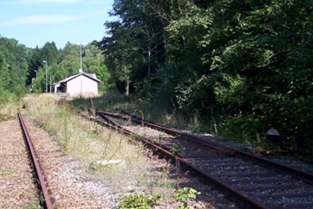
website: website: website: website: website: Owner of the abandoned railway: State of Lower Austria Owner of the abandoned railway: State of Lower Austria Owner of the abandoned railway: Owner of the abandoned railway: Owner of the abandoned railway: Owner of the abandoned railway: Owner of the abandoned railway: State of Lower Austria State of Lower Austria State of Lower Austria State of Lower Austria State of Lower Austria gpx file: gpx file: gpx file: gpx file: gpx file: The potential greenway with a total distance of around 15 kilometers along the former railway line. The villages of Palterndorf, Dobermannsdorf, Gösting, Zistersdorf, Eichhorn, Loidesthal, Blumenthal, Windisch-Baumgarten, Großinzersdorf and Gaiselberg will be integrated into the cycle path network. The potential greenway with a total distance of around 15 kilometers along the former railway line. The villages of Palterndorf, Dobermannsdorf, Gösting, Zistersdorf, Eichhorn, Loidesthal, Blumenthal, Windisch-Baumgarten, Großinzersdorf and Gaiselberg will be integrated into the cycle path network. The potential greenway with a total distance of around 15 kilometers along the former railway line. The villages of Palterndorf, Dobermannsdorf, Gösting, Zistersdorf, Eichhorn, Loidesthal, Blumenthal, Windisch-Baumgarten, Großinzersdorf and Gaiselberg will be integrated into the cycle path network. site Total distance: 6436 mTotal climbing: 0 mTotal descent: 0 m Total distance: 6436 m Total distance: 6436 m Total climbing: 0 m Total climbing: 0 m Total descent: 0 m Total descent: 0 m The connections to the international Eurovelo9 and the Kamp-Thaya-March-Radweg (KTM): There is a direct connection between the new cycling facility and the regional “Muskateller” and “Traminer” cycle routes, as well as the connection to the international cycle route Eurovelo 9 from Vienna to Breclav and to the Lower Austrian main cycle route Kamp-Thaya-March-Radweg. These connections indicate that the new greenway, cycle path or special heritage will be linked to existing cycling routes and this will provide more options for recreational cycling and tourism. Retrieved from Google Maps. Unused railway station on Dobermannsdorf Retrieved from Google Maps. Unused railway station on Dobermannsdorf Retrieved from Google Maps. Unused railway station on Dobermannsdorf Retrieved from Google Maps. Unused railway station on Dobermannsdorf Retrieved from Google Maps. Unused railway station on Dobermannsdorf Retrieved from Google Maps. Unused railway station on Dobermannsdorf Retrieved from Google Maps. Unused railway station on Dobermannsdorf Retrieved from Google Maps. Unused railway station on Dobermannsdorf The railway between Dobermannsdorf and Loidesthal is planned to be repurposed as a greenway, offering a variety of sport and leisure activities such as cycling, walking, hiking, rollerblading, skateboarding, wildlife and nature observation and picnics. The greenway will also connect different villages and communities, providing a safe and scenic route for visitors and locals. It will also be connected to existing cycling routes, offering more options for recreational cycling and tourism. There are also tourist attraction centers on the former railway line such as Wehrturm, Memorial Park Kriegerdenkmal bei Wallfahrtskirche Maria Moos, Weinpresse Hauerbaum. (The touristic areas on the route were researched on Google earth.) The railway between Dobermannsdorf and Loidesthal is planned to be repurposed as a greenway, offering a variety of sport and leisure activities such as cycling, walking, hiking, rollerblading, skateboarding, wildlife and nature observation and picnics. The greenway will also connect different villages and communities, providing a safe and scenic route for visitors and locals. It will also be connected to existing cycling routes, offering more options for recreational cycling and tourism. There are also tourist attraction centers on the former railway line such as Wehrturm, Memorial Park Kriegerdenkmal bei Wallfahrtskirche Maria Moos, Weinpresse Hauerbaum. (The touristic areas on the route were researched on Google earth.) The railway between Dobermannsdorf and Loidesthal is planned to be repurposed as a greenway, offering a variety of sport and leisure activities such as cycling, walking, hiking, rollerblading, skateboarding, wildlife and nature observation and picnics. The greenway will also connect different villages and communities, providing a safe and scenic route for visitors and locals. It will also be connected to existing cycling routes, offering more options for recreational cycling and tourism. There are also tourist attraction centers on the former railway line such as Wehrturm, Memorial Park Kriegerdenkmal bei Wallfahrtskirche Maria Moos, Weinpresse Hauerbaum. (The touristic areas on the route were researched on Google earth.) (The touristic areas on the route were researched on Google earth.) Potential users of the railway greenway include local residents, cyclists, walkers/hikers, rollerbladers/ skateboarders, families, nature enthusiasts, and tourists. The greenway offers safe, convenient, and scenic options for transportation, recreation, and nature observation. The municipality of Zistersdorf, the market town of Palterndorf – Dobermannsdorf and the state of Lower Austria have decided to expand the no longer used railway line between the two municipalities for cyclists and thus connect the municipalities. Potential users of the railway greenway include local residents, cyclists, walkers/hikers, rollerbladers/ skateboarders, families, nature enthusiasts, and tourists. The greenway offers safe, convenient, and scenic options for transportation, recreation, and nature observation. The municipality of Zistersdorf, the market town of Palterndorf – Dobermannsdorf and the state of Lower Austria have decided to expand the no longer used railway line between the two municipalities for cyclists and thus connect the municipalities. Potential users of the railway greenway include local residents, cyclists, walkers/hikers, rollerbladers/ skateboarders, families, nature enthusiasts, and tourists. The greenway offers safe, convenient, and scenic options for transportation, recreation, and nature observation. The municipality of Zistersdorf, the market town of Palterndorf – Dobermannsdorf and the state of Lower Austria have decided to expand the no longer used railway line between the two municipalities for cyclists and thus connect the municipalities.

The Dobermannsdorf – Loidesthal Read More »

Hainfeld – Weißenbach an der Triesting, part of the LeobersdorferBahn that connected the Triestingtal and the Gölsental

website: website: website: website: website: Owner of the abandoned railway: The Lower Austrian Southwest Railways (NÖSWB) Owner of the abandoned railway: The Lower Austrian Southwest Railways (NÖSWB) Owner of the abandoned railway: Owner of the abandoned railway: Owner of the abandoned railway: Owner of the abandoned railway: Owner of the abandoned railway: The Lower Austrian Southwest Railways (NÖSWB) The Lower Austrian Southwest Railways (NÖSWB) The Lower Austrian Southwest Railways (NÖSWB) The Lower Austrian Southwest Railways (NÖSWB) The Lower Austrian Southwest Railways (NÖSWB) gpx file: gpx file: gpx file: gpx file: products gpx file: The railway line called “Weissenbach-Hainfeld” was opened in 1877 and was part of the Lower Austrian Southwest Railways (NÖSWB). It was almost 25 km long and was a single-track line with 3 intermediate stations, Altenmarkt-Thenneberg, Kaumberg, and court mountain and also had other stops, Kaumberg Markt, Altenmarkt an der Triesting, Tasshof, and Eberbach-Hocheck. The railway line was closed in 2004 and the tracks have been dismantled since 2015. One of the railway heritage of this railway is the concrete bridge over Hainfelder Straße (B18) over the Triesting at kilometer 28. Another important heritage of this railway is the Altenmarkt-Thenneberg station, located at kilometer 26.4 which had three through tracks and a short dead end track to the west, whose switch can be seen in front of the station building. Along the route, the bridge over the Triesting at kilometer 19.8 is also relatively new and it’s an important part of the railway heritage. Additionally, the Alter Gerichtsberg Tunnel and the Gerstbach Brücke are other significant heritage of this railway that are still preserved today. The railway line called “Weissenbach-Hainfeld” was opened in 1877 and was part of the Lower Austrian Southwest Railways (NÖSWB). It was almost 25 km long and was a single-track line with 3 intermediate stations, Altenmarkt-Thenneberg, Kaumberg, and court mountain and also had other stops, Kaumberg Markt, Altenmarkt an der Triesting, Tasshof, and Eberbach-Hocheck. The railway line was closed in 2004 and the tracks have been dismantled since 2015. One of the railway heritage of this railway is the concrete bridge over Hainfelder Straße (B18) over the Triesting at kilometer 28. Another important heritage of this railway is the Altenmarkt-Thenneberg station, located at kilometer 26.4 which had three through tracks and a short dead end track to the west, whose switch can be seen in front of the station building. Along the route, the bridge over the Triesting at kilometer 19.8 is also relatively new and it’s an important part of the railway heritage. Additionally, the Alter Gerichtsberg Tunnel and the Gerstbach Brücke are other significant heritage of this railway that are still preserved today. Total distance: 23818 mTotal climbing: 0 mTotal descent: 0 m Total distance: 23818 m Total distance: 23818 m Total climbing: 0 m Total climbing: 0 m Total descent: 0 m Total descent: 0 m Horse breeding farm along the route: Part of the Triesting Gölsental cycle route If the former railway line were to be converted into a greenway or cycle path, it could be used for a variety of sport and leisure activities. The relatively flat and smooth surface of the former railway line, along with its winding route through the mountainous region of the Triestingtal, would make it an ideal location for cycling. It could be used by both recreational and more serious cyclists for exercise, sightseeing, and commuting. The greenway or cycle path could also be used for hiking and walking. The winding route through the mountainous region of the Triestingtal would provide a scenic and relatively easy path for these activities. The route would provide a scenic and relatively easy walk through the mountainous region and could be enjoyed by people of all ages and abilities. Also, it could be a great opportunity for nature watching, birdwatching, wildlife observation, horseback riding, providing an opportunity for equestrian enthusiasts to explore the area on horseback. Additionally, it could also be used for rollerblading, skateboarding, scootering, and in line skating. If the former railway line were to be converted into a greenway or cycle path, it could be used for a variety of sport and leisure activities. The relatively flat and smooth surface of the former railway line, along with its winding route through the mountainous region of the Triestingtal, would make it an ideal location for cycling. It could be used by both recreational and more serious cyclists for exercise, sightseeing, and commuting. The greenway or cycle path could also be used for hiking and walking. The winding route through the mountainous region of the Triestingtal would provide a scenic and relatively easy path for these activities. The route would provide a scenic and relatively easy walk through the mountainous region and could be enjoyed by people of all ages and abilities. Also, it could be a great opportunity for nature watching, birdwatching, wildlife observation, horseback riding, providing an opportunity for equestrian enthusiasts to explore the area on horseback. Additionally, it could also be used for rollerblading, skateboarding, scootering, and in line skating. If the former railway line from Weissenbach to Hainfeld via the court mountain were to be converted into a greenway or cycle path, it could be used by a variety of potential users such as recreational and serious cyclists, hikers and walkers, nature enthusiasts, equestrian enthusiasts, families, tourists, rollerblading, skateboarding, Scootering enthusiasts for leisure, exercise, transportation, nature watching, birdwatching, wildlife observation, and as a destination for tourists. The success and popularity of the greenway or cycle path will depend on a variety of factors including location, accessibility, safety, and maintenance. (

Hainfeld – Weißenbach an der Triesting, part of the LeobersdorferBahn that connected the Triestingtal and the Gölsental Read More »

Local train Siedenbrunn-Engelhartstetten

website: Wikipedia Owner of the abandoned railway: The Lower Austrian State Railways / Niederösterreichische Landesbahnen gpx file: download The Local train Siebenbrunn-Engelhartstetten was a narrow-gauge railway line operated in Austria; it was built in 1894 and closed in 1955. According to its Wikipedia page, the railway had several notable heritage features, such as tunnels, bridges, and stations. The Engelhartstetten Tunnel, which is almost 600 meters long, is one of Austria’s longest narrow-gauge railway tunnels. The Siebenbrunner Viaduct, which spans the Wien River, is regarded as a technological marvel of its era. The railway’s main station, Siebenbrunn, was equipped with a turntable, workshops, and a water tower. (https://de.wikipedia.org/wiki/Lokalbahn_Siebenbrunn%E2%80%93Engelhartstetten#Weblinks)According to a tourism website, the route of this railway has several worth-seeing features, including the Siebenbrunn station, which is preserved as a museum, the Siebenbrunner Viaduct, a technical masterpiece that spans the Wien River, and the scenic countryside of Lower Austria offering picturesque views. (https://www.lower-austria.info/infrastructure/a-train-station-siebenbrunn-leopoldsdorf) Railway line: 188 / Siebenbrunn-Leopoldsdorf – Breitenstetten – Engelhardtstetten; 22 km (1435 mm) and 189 / Breitenstetten – Orth ad Donau 6 km (1435 mm) Route:            Leopoldsdorf – Breitstetten – Orth and Engelhartstetten – Loimersdorf – Kopfstetten Route length (single): About 13.4 km Surface: asph. (Width: 3m) In Orth an der Donau, there are the famous schlossORTH and museumORTH. In addition, the market town of Engelhartstetten is home to the two most prominent Baroque palaces: Schloss Hof and Niederweiden Palace. (https://www.noe-landesausstellung.at/en/excursion-tips/spotlight-on-the-marchfeld-region) Credits: Herbert Ortner, 1992. The railway route passed through the scenic countryside of Lower Austria, offering picturesque views of the surrounding landscape. Given this information, it’s likely that the former railway route could be used for a variety of sport and leisure activities:   Hiking: The railway route passes through the countryside of Lower Austria, which is known for its beautiful landscape and countryside, this could make the region an attractive destination for hiking. Cycling: Since the railway is closed, the tracks could be converted into a cycling trail, allowing people to bike through the picturesque landscape of Lower Austria. Heritage and Cultural Tours: The railway had several notable heritage features, such as tunnels, bridges, and stations, which could be visited as part of a heritage or cultural tour. Photography: The railway route passes through the scenic countryside of Lower Austria, offering picturesque views of the surrounding landscape. It could be used for photography enthusiasts. Credits: Herbert Ortner, 2016. Potencial activities are hiking, cycling, ecological and educational excursions, walking and trekking, and jogging are just a few of the sports and activities that might be carried out on the former railway. Parts of the road were reopened as a pedestrian and cycling path in 2019. On May 25, 2019, the Kopfstetten-Loimersdorf-Engelhartstetten segment opens. The Leopoldsdorf-Breitstetten-Orth segment opened a week later, on June 2, 2019.

Local train Siedenbrunn-Engelhartstetten Read More »