Zlaté Moravce – Lužianky railway
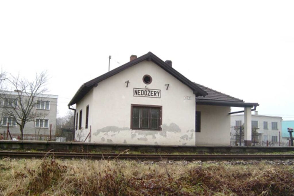
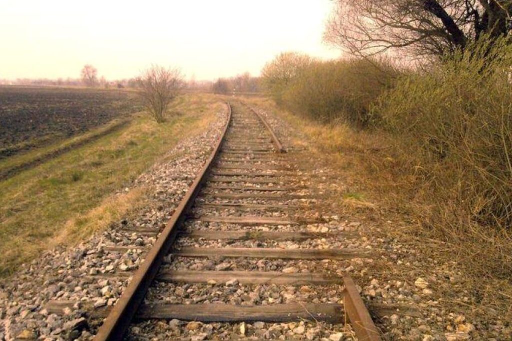
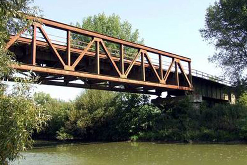
website: website: website: website: website: Owner of the abandoned railway: Slovak Republic Railways (Železnice Slovenskej republiky) Owner of the abandoned railway: Slovak Republic Railways (Železnice Slovenskej republiky) Owner of the abandoned railway: Owner of the abandoned railway: Owner of the abandoned railway: Owner of the abandoned railway: Owner of the abandoned railway: Slovak Republic Railways (Železnice Slovenskej republiky) Slovak Republic Railways (Železnice Slovenskej republiky) Slovak Republic Railways (Železnice Slovenskej republiky) Slovak Republic Railways (Železnice Slovenskej republiky) Slovak Republic Railways (Železnice Slovenskej republiky) gpx file: gpx file: gpx file: gpx file: gpx file: There are 6 stations between Lužianky and Zlaté Moravce (Drážovce, Podhorany, Žirany, Jelenec, Ladice, Sľažany). It simultaneously crosses the flat area of south Slovakia and also the hilly area of central Slovakia (Tribeč mountains). There are several bridges over the railway, viaducts on the rail too. There is a bridge over the river Nitra. There are 6 stations between Lužianky and Zlaté Moravce (Drážovce, Podhorany, Žirany, Jelenec, Ladice, Sľažany). It simultaneously crosses the flat area of south Slovakia and also the hilly area of central Slovakia (Tribeč mountains). There are several bridges over the railway, viaducts on the rail too. There is a bridge over the river Nitra. There are 6 stations between Lužianky and Zlaté Moravce (Drážovce, Podhorany, Žirany, Jelenec, Ladice, Sľažany). It simultaneously crosses the flat area of south Slovakia and also the hilly area of central Slovakia (Tribeč mountains). There are several bridges over the railway, viaducts on the rail too. There is a bridge over the river Nitra. There are 6 stations between Lužianky and Zlaté Moravce (Drážovce, Podhorany, Žirany, Jelenec, Ladice, Sľažany). It simultaneously crosses the flat area of south Slovakia and also the hilly area of central Slovakia (Tribeč mountains). There are several bridges over the railway, viaducts on the rail too. There is a bridge over the river Nitra. Total distance: 32231 mTotal climbing: 175 mTotal descent: -145 m Total distance: 32231 m Total distance: 32231 m Total climbing: 175 m Total climbing: 175 m Total descent: -145 m Total descent: -145 m Tribeč area offers many interesting hiking paths close to the city Nitra and can be accessible from the railway. Tribeč is also very popular with mountain bikers since there are a lot of paths interweaving the hills. Intermodality: Lužianky station can be reached from Nitra by train and the train station is directly next to the bus station in Nitra. In Zlaté Moravce, stations are within 1,2 km from each other. Credits: https://kzmbojnice.railnet.sk/zastavka-nedozery-na-moduloch/ Considering the characteristics, the main activities are: cycling, walking, running, trekking, nordic walking, hiking, skating, mountain biking. Credits: https://kzmbojnice.railnet.sk/zastavka-nedozery-na-moduloch/ Since the railway is located in a flat area of the country mostly in a close proximity to the river Váh, it could be potentially visited by all people, even with reduced mobility. There is no steep incline and it should be accessible by anyone. There is no plan in action at the moment. Passenger transport was cancelled, it may still be used for cargo transport. Tribeč area offers many interesting hiking paths close to the city Nitra and can be accessible from the railway. Tribeč is also very popular with mountain bikers since there are a lot of paths interweaving the hills. Intermodality: Lužianky station can be reached from Nitra by train and the train station is directly next to the bus station in Nitra. In Zlaté Moravce, stations are within 1,2 km from each other. Credits: https://kzmbojnice.railnet.sk/zastavka-nedozery-na-moduloch/ Considering the characteristics, the main activities are: cycling, walking, running, trekking, nordic walking, hiking, skating, mountain biking. Credits: https://kzmbojnice.railnet.sk/zastavka-nedozery-na-moduloch/ Since the railway is located in a flat area of the country mostly in a close proximity to the river Váh, it could be potentially visited by all people, even with reduced mobility. There is no steep incline and it should be accessible by anyone. There is no plan in action at the moment. Passenger transport was cancelled, it may still be used for cargo transport. Tribeč area offers many interesting hiking paths close to the city Nitra and can be accessible from the railway. Tribeč is also very popular with mountain bikers since there are a lot of paths interweaving the hills. Intermodality: Lužianky station can be reached from Nitra by train and the train station is directly next to the bus station in Nitra. In Zlaté Moravce, stations are within 1,2 km from each other. Credits: https://kzmbojnice.railnet.sk/zastavka-nedozery-na-moduloch/ Considering the characteristics, the main activities are: cycling, walking, running, trekking, nordic walking, hiking, skating, mountain biking. Credits: https://kzmbojnice.railnet.sk/zastavka-nedozery-na-moduloch/ Since the railway is located in a flat area of the country mostly in a close proximity to the river Váh, it could be potentially visited by all people, even with reduced mobility. There is no steep incline and it should be accessible by anyone. There is no plan in action at the moment. Passenger transport was cancelled, it may still be used for cargo transport. Tribeč area offers many interesting hiking paths close to the city Nitra and can be accessible from the railway. Tribeč is also very popular with mountain bikers since there are a lot of paths interweaving the hills. Intermodality: Lužianky station can be reached from Nitra by train and the train station is directly next to the bus station in Nitra. In Zlaté Moravce, stations are within 1,2 km from each other. Credits: https://kzmbojnice.railnet.sk/zastavka-nedozery-na-moduloch/ Considering the characteristics, the main activities are: cycling, walking, running, trekking, nordic walking, hiking, skating, mountain biking. Credits: https://kzmbojnice.railnet.sk/zastavka-nedozery-na-moduloch/ Since the railway is located in a flat area of the country mostly in a close proximity to the river Váh, it could be potentially visited by all people, even with reduced mobility. There is no steep incline and it should be accessible by anyone. There is no plan in action at the moment. Passenger transport was cancelled, it may still be used for cargo transport. Tribeč area offers many interesting hiking paths close to the city Nitra and can be accessible from the railway. Tribeč is also very popular with
Zlaté Moravce – Lužianky railway Read More »